This is part three of my journey through Nepal. Go back to part one, two.
Namche Bazaar, Tengboche and Dingboche
Having gone across the many passes and valleys of the middle hills, the trek suddenly takes on a different character once you pass the Lukla airport. There are many, many more people on the trail, and the trail now follows the Dudh Kosi river, going gently upward. Upward progress is now for real since there are no more intervening valleys between here and the high country.
Trekkers must go slowly here in order to acclimatize to the ever increasing altitude. Most people stop for two or three days in Namche Bazaar (3450 m), spend one night near the Tengboche monastery (3800 m), followed by two nights in Dingboche or Periche (4250 m). This is the minimum acclimatization schedule that allows most, but certainly not all, people to make the return trip from Lukla airport to Kala Pattar in two weeks.
Many trekkers I met in this area were on this schedule. I saw people waking up with a headache (early sign of HACE, a form of altitude sickness that can be lethal in hours) and decide to go onward and upward because otherwise they would not ‘make it’. I saw people being dragged down to lower altitude by their guides, people who were nearly unconscious, their legs dangling uselessly beneath them. I saw a trekking guide put a client in a Gamow bag and assure her she would be ‘cured’ of her altitude sickness and that she would be able to join her group for an ascent of Gokyo Ri later that morning. The Gamow bag is supposed to be used to temporarily relieve symptoms of altitude sickness to allow a person to descend to safety. I saw people hiking down with expressions on their faces that looked like they had been to war. I saw the Nepali army rescue helicopter make flights several times a day, flying out the injured and the dead at $5000 U.S. a pop.
There is no shame in getting sick or injured, but few of these people seemed like they were enjoying themselves, and I think that’s what they came here for in the first place. Even though these people may have brought home spectacular pictures, the stress they experienced probably took much away much of the fun. Even though I had read about the dangers I didn’t expect a scene like this. I was sure glad that I had lots of time, that I had the option of turning back and trying again, and that I didn’t have a plane to meet. Extra time acclimatizing doesn’t mean you have to lie in your sleeping bag and stare at the walls of your tent. There are lots of things to do and see here.
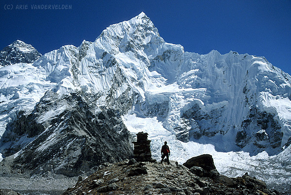
Namche Bazaar.
Namche Bazaar is the hub of the Solu-Khumbu area. Trails to Lobuje, Gokyo, Chukung, and Jiri radiate outwards. Trekkers stop here to acclimatize, and Nepalis buy and sell housewares and farm produce at the weekly market. The peak sticking up on the skyline is Ama Dablam.

Trekkers in Namche Bazaar.
Some trekkers I spent many evenings with on the Jiri-Namche Trek. We talked, ate, and played a lot of cards. Left to Right: Kim Spencer, Nalam Lama, and Trevor Siteman (two Nova Scotians and their guide), Nara Bahadur Bohara, Anke and Niels (German couple), and crouching in front is Arie van der Velden.

Sunrise over Everest and Lhotse.
One morning we got up before dawn and hiked up a hill above Namche to watch the sunrise. It was frosty and clear, and plumes blowing off of the summits of Lhotse (left) and mount Everest (right) signify high winds aloft.

Prayer wheels, Khumjung.
Nara spins prayer wheels at the Khumjung monastery.

Monks erecting a prayer flag pole.
These monks are busying themselves outside Tengboche monastery on a cloudy, cold afternoon. Later that day inside the monastery, I watched monks construct a sand mandala. One of the monks signaled me to come sit beside him, and I watched the monks carefully spread dyed sand on a patterned board, constructing colorful patterns with deep meanings.

Stupa at Dingboche.
This stupa is located just outside of Dingboche on a hillside. In the background is Kantega.

Taboche.
Afternoon clouds veil Taboche, an impressive peak that towers over the Dingboche – Periche area.

View from Dingboche toward the Cho La.
From the hill above Dingboche there is a view toward the Cho La (little glacier shaped like a < in the distance) which is a shortcut to the Gokyo area. Beneath Loboje East (peak on right) is the trail to Lobuje and Kala Pattar.

Chukung and mount Ama Dablam
On the way to Mount Everest, travelers pass a striking peak called Ama Dablam. At 6856 m, its summit is a full 2 km lower than that of Mount Everest. But, as they say, size isn’t everything. At the foot of Ama Dablam and just a short distance off the Everest trail is a little village called Chukung. It makes a great base for doing some exploring, some scrambling, and enjoying some of the most spectacular mountain scenery anywhere on our planet.
Ama Dablam, from Pangboche.
The awesome south face of Ama Dablam towers over the Pangboche area. Mani stones are stacked beside the spur trail that leads to the main village of Pangboche.

Ama Dablam, closeup.
Near the summit block of Ama Damlam are several clumps of glacier ice that cling precariously to the steep south face. These form the necklace of Ama Dablam, which means “Mother and her necklace.”

Summit of Chukung Ri.
A cairn and prayer flags mark the summit of Chukung Ri. This was our first scrambling summit in the Khumbu area.

Ama Dablam, from the summit of Chukung Ri.
A tremendous view of the north and east faces of Ama Dablam. On the left is the Chukung glacier, a mile-high wall of seracs capped by a fluted ice wall. Nara and I ascended the moraine that runs to the base of the ice (center) to get a closer view (see below).

Descending Chukung Ri.
Nara is descending from Chukung Ri on platy, greasy shale, a bit of an anomaly in this area where most rock is heavily metamorphosed. In the background is Lhotse and the Lhotse – Nuptse ridge.

Creek crossing.
On our approach to the Chukung glacier moraine, we needed to cross this little creek. We walked alongside it a ways, looking for a good place to cross, but everywhere it was just to far to jump across and too deep and fast running to wade. Until we found this bridge, that is, built entirely out of stacked stones. From here, the moraine (right center) was just a stone’s throw away.

Chukung Glacier.
From the top of the moraine, there was a tremendous view across the Chukung glacier. A fluted icewall caps the glacier above the bergschrund. It was a perfect day; the sky was blue, the air was still, and it was very quiet except for the odd creak and groan from the nearby glaciers.

East face, Ama Dablam.
The east face of Ama Dablam, from the lower slopes of Chukung Ri.

Lobuje, and Mount Everest from Kala Pattar
Near Everest basecamp, tucked in a little meadow at the side of the Khumbu glacier, is the little village of Lobuje. Lobuje has been called “the armpit of Nepal”, but nothing could be further from the truth. Although the elevation of 4950 m makes many people miserable, spectacular mountain views abound, and although the biffy wasn’t pretty I certainly saw a lot worse elsewhere in Nepal.
Everest basecamp is just a short distance away from Lobuje, but most people skip basecamp in favour of an ascent of Kala Pattar, as did I. Although the basecamp site may be convenient for climbers, you can’t see the summit from there. Also, in the fall of 2001 there were no expeditions on the mountain.
Morning light on Pumo Ri.
Pumo Ri is a striking pyramidal peak towering over the west side of the Khumbu valley. The dark shape in the foreground is Kala Pattar, a scree pile ascended by tourists that offers tremendous views of Mount Everest and its neighbors.

Mount Everest, from Kala Pattar.
This is the famous view of Mount Everest that everyone comes to see. The glacier-clad mountain on the right is Nuptse. The rock tower in the background is mount Everest (8848 m), and the pyramidal shaped mountain in front of it is its west ridge. As the Khumbu glacier wraps around Nuptse it forms the infamous Khumbu icefall, a treacherous area which climbers bound for Everest must negotiate.

Mount Everest, summit block.
Climbers ascend the mountain via the right skyline ridge. Everest buffs who have read Krakauer’s “Into thin air” will recognize the south col (center right), the south summit (pimple just right of the true summit where the angle lays back), and the Hillary Step (little notch halfway between the south summit and true summit).

On top of Kala Pattar.
Nara and I on top of Kala Pattar (5600 m). In the background is Pumo Ri. The place where we are standing is a little precarious. The next picture below shows the tremendous drop-off that is less than a meter behind us.

Pumo Ri and Kala Pattar.
Pumo Ri forms a dramatic backdrop to Kala Pattar. The rubble slope leading up to the top of Kala Pattar comes to an abrupt end (see previous picture), halting keen scramblers who want an even bigger view. If you look closely, you can see people heading to and from the top.

Nuptse.
The view from the top of Kala Pattar is spectacular, but it is a busy place. After a while we wandered down toward Pumo Ri basecamp and found some more peaceful surroundings. The light on Nuptse kept improving as the day went on. The many tiers of glaciers and icefalls that cling to Nuptse’s west face makes for the most stunning mountain vista I’ve ever seen.
Yak and Kantega.
A yak grazing, near Lobuje. The mountain in the background is Kantega.

Khumbu valley.
A look back at the Khumbu valley, while on the way to Cho La and Gokyo.

Cho Oyu and Everest views from the Gokyo area
The Gokyo valley lies just to the west of mount Everest. Its valley bottom is entirely occupied by the Ngozumpa glacier, a grey, rubbly tongue of ice flowing south from the slopes of Cho Oyu. The lateral moraines at the side of the glacier block off drainage from side valleys on the west side, and as a result these side valleys are filled with lakes.
The resort town of Gokyo lies on the shores of third Gokyo lake, a beautiful turquoise body of water. Most tourists who visit Gokyo ascend Gokyo Ri, a scree pile just opposite the village that offers views of mount Everest, Lhotse, Makalu and Cho Oyu – four of the world’s fourteen peaks over 8000 m. Visitors who want more solitude can escape the crowds of Gokyo Ri and head north to fourth and fifth Gokyo lakes, and at the foot of Cho Oyu there are a few ponds known as sixth lakes. There is a lot of area to do off-trail exploration here. Two mountains in this area that are regularly ascended by scramblers are Nameless Fangs and Knobby View. Each of these summits offers tremendous views of a lunar landscape of rock, ice and sky.
Gokyo Lake, from the slopes of Gokyo Ri.
The hike up Gokyo Ri offers great views of Gokyo and its surroundings. The peak in the background is Cholatse.

Everest from Gokyo Ri.
The view from Gokyo Ri reveals the north ridge (skyline to the left of Everest’s summit). This is the route climbers follow when ascending from the Tibetan side of the mountain. Early attempts to climb mount Everest by Norton and Mallory in the 1920’s and by Tilman, Shipton and Smythe in the late 1930’s were on this route. Around 1950, Nepal opened up to foreigners and the Chinese shut down access to Tibet, and this route was largely abandoned by westerners. In recent years this route has become popular again because of the large expedition fees that the Nepali government has been charging.

Nara on Knobby View.
Partway up Knobby View I “bonked”, my energy reserves suddenly hit zero. I managed to drag my butt up to a large cairn decorated with prayer flags, but there was one more “knob” to go, perhaps 10-20 m higher (behind Nara). It looked steep and loose, and with my enthusiasm gone I decided to skip it. Judging by the size of the cairn we were at, most people probably do the same. The views were awesome. Behind Nara and the last knob is Cho Oyu (8201 m).

Everest and the Kangchung peaks from Knobby View.
Knobby View (about 5500 m) is probably one of the most strategic viewpoints in the whole Everest area that is accessible to non-climbers. In the foreground the Guybanare glacier joins the main Ngozumpa glacier, leaving a sharp lateral moraine at its margin. The two Kangchung peaks soar above the Guybanare glacier (center right). In the distance Everest and its neighbors are visible (center left).

Clopseup of Everest, from Knobby View.
From this aspect part of the Lhotse face is visible, which is hidden from view at many other viewpoints in the Khumbu area. The rocky protrusion in the centre of the face is the Geneva Spur. Climbers ascending from the Nepal side typically climb the Lhotse face to the right of the Geneva Spur, and then cut across it to reach the South Col. The peak to the right of Lhotse is Makalu (8462 m)

More views from Knobby View.
A view to the northeast toward the Nup La (center left), a 5958 m pass into Tibet. The peak in the centre of the picture is unnamed on my map (7020 m).

Cho Oyu by moonlight.
This is an eight minute exposure of Cho Oyu, the shores of Gokyo lake and the lower slopes of Gokyo Ri, bathed in moonlight. The stars in the sky cause streaks because of the rotation of the earth; only Polaris appears stationary.

Renja La.
This picture clearly shows how the glacier and moraines dam up Gokyo lake. Everest, Lhotse and Makalu form the skyline. This picture is taken from the slopes leading up to the Renja La, a 5435 m pass to the Bhote Kosi valley and to Thami.

Go to part four of my journey through Nepal.