This is part two of our Nakasendo hike. Go back to part 1.
Miyanokoshi to Kiso-Fukushima
We took a train from Narai to Miyanokoshi. We could have started our walk at Yabuhara, one stop earlier, but this would have meant a long slog along the highway since there are few secondary roads. I wasn’t sure if all tunnels could be bypassed. In any case, we skipped this section and started our day at Miyanokoshi.
From Miyanokoshi station we walked to the southwest. At the edge of town there are three choices: a concrete road that goes through rice paddies; route 267 which goes along the south side of the railway; or cross the tracks and walk through a village. We walked the road through the rice paddies, which was quite scenic until it led through a concrete plant. One of the other options would have been better. In any case, route 267 crosses to the north of the tracks about 2.5 km southwest of Miyanokoshi station. We followed route 267 into Harano, where it becomes the old Nakasendo road. Just past Harano station there is a marker to indicate the halfway point between Edo and Kyoto.
At the Seisougo River the Nakasendo peters out and a trail leads through a bamboo grove down to the river.

We crossed the river on a very rickety bridge. We decided to cross one at a time.

Past the bridge, the trail leads up to a road, which is the Nakasendo. We followed the Nakasendo for about 750 m and turned right, crossing the railway on a bridge (Uedagakkokosen Bridge). It is possible to continue straight on the Nakasendo to pick up bits and pieces of it along both sides of the highway, but we would have ended up hiking along the highway for some distance. Instead, we abandoned the Nakasendo and hiked on the north side of the Kiso River, following a quiet road with good views across the valley. At this point wet snow was coming down and I put away my camera. We kept our heads down as we walked the final few kilometers into Kiso-Fukushima.
Kiso-Fukushima
Kiso-Fukushima is the largest town in the Kiso valley. It is a regional center and has shops and supermarkets. There are several sake breweries, and there are several ryokan (Japanese style hotels) to choose from.
We stayed two nights in Kiso Mikawaya. The floor of our room was covered with tatami mats, and futons are laid out for sleeping. There was a low table and chairs without legs for relaxing.

Sleeping on a thin futon is a challenge for westerners who are used to thick mattresses. Whenever we stayed in traditional Japanese lodgings I’d rummage through all of the closets to see if there were any spare futons. In most cases we were able to double them up.
Our ryokan overlooked the river, and we could faintly hear the sound of the rushing water in our room. I imagine in the summertime with the windows open it would be quite nice, but it was cold outside when we visited. In the morning when we woke, up, we spotted a troupe of macaque monkeys jumping from rooftop to rooftop across the river. Diana managed to grab her camera in time to take a quick snapshot.

In the basement was the onsen (communal spa bath). We dressed in yukata prior to going downstairs.

Dinner at our ryokan was an elaborate affair. Dinner included shabu-shabu (hotpot), tempura, sashimi, an assortment of pickles, miso soup, rice, soba noodles, and more, all beautifully presented. Breakfast included much of the same foods.

We spent a day walking around Kiso Fukushima. We started at Kozen-ji, a temple just down the road from our ryokan.
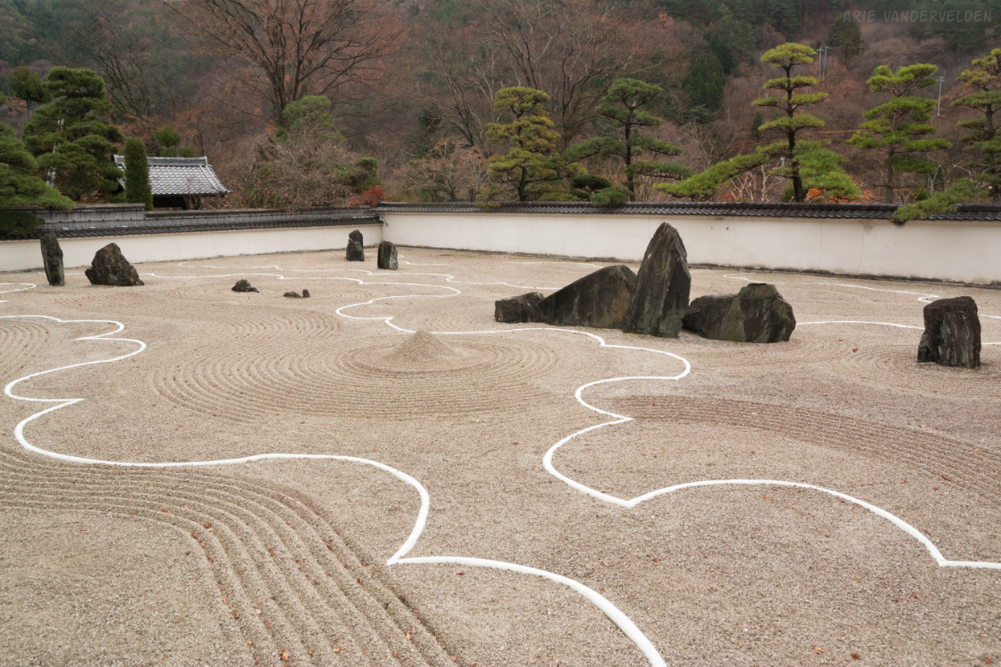
The temple claims to have “the largest zen rock garden in Asia.” I’m not quite sure how to interpret the various elements of the rock garden, but I think they represent landscape elements such as rippled water, mountains, and clouds.
After our visit to Kozen-ji we headed into town to find pieces of the old Nakasendo Road. This bench was engraved with the signs for Nakasendo.

Veggies for sale.

Persimmons drying.

Twine sandals.

Snow squalls were threatening as we photographed this temple.

We passed a sake brewery.

In the center of town is a footbath with scalding-hot water. It feels nice after hiking on a cold day.
Kiso-Fukushima to Agematsu
We hiked this section both in 2017 and 2023. In 2017 we got hopelessly lost and ended up hiking a long section along the highway. We came better prepared in 2023.
Past Kiso-Fukushima train station, the Nakasendo is essentially the first road or alley east of the tracks. About 1.8 km south of the station, we followed a road underneath the elevated highway. The trail led upwards, going in switchbacks past some houses. The trail then follows a forest track to the south. at a Y-juncion, we took the right branch which descended back down to the highway.
We crossed the highway on a crosswalk and walked along the highway for about 400 m. We recrossed the highway at the route 20 junction, and 50 m further on we followed an underpass underneath the train tracks. At The T we went right, to the south, on a quiet road leading past some houses. After about 1.3 km the trail leads through a hamlet. At the hamlet, the main highway crosses the river on a bridge, while the Nakasendo follows a road on the east side of the river. In a short distance, this road leads to a red bridge.

We crossed the red bridge and hiked uphill on a switchback. There is some confusing signage here, and it’s easy to get lost. In essence, the situation is this. There are three roads on the west side of the river: route 508 along the river; a middle road, and the major highway up above. The best road for walking is the middle smaller road. After about 1.6 km it crosses the highway on an overpass. The next section is particularly lovely, with great views of Agematsu and the surrounding mountains.

All to soon, the road descends down to the river, crosses it on a bridge, and enters the town of Agematsu. Up ahead is an area of road spaghetti, including a circling flyover. To avoid most of this, take the first left after the bridge, and walk through the village to an underpass underneath the train tracks. On the other side of the tracks is an intersection with traffic lights. Cross kitty-corner, walk east a few meters, cross a small bridge, and turn left. You are now on the Nakasendo. The Nakasendo can be followed for a long way through Agematsu – all the way to the village of Nezame. There are some beautiful historic buildings along the way.


Along the way we saw banners depicting local sumo wrestler Mitakeumi. Mitakeumi has had a long career in professional sumo, and he has won the Emperor’s Cup three times. Impressive! The locals must be proud of him.

We ended this leg of our hike in Nezame. It is possible to hike on for another 1.2 km or so, crossing the Nameri River. The Nakasendo then ends at the highway.
Continue to part three of our Nakasendo hike.
Logistics
- In Kiso-Fukushima we stayed at Kiso Mikawaya. It has spacious rooms and nice facilities. In 2017 the food was excellent, but in 2023 the dinner and breakfast were much more basic. Still, I recommend this ryokan.
- In Agematsu we stayed at Hotel Nezame. It has comfortable rooms, a nice onsen, courteous staff, and the food is excellent. Highly recommended.
Miyanokoshi station to Kiso Mikawaya ryokan in Kiso-Fukushima is 8.5 km. Add on another 1.2 km if going to Kiso-Fukushima station.
Kiso Mikawaya to Notel Nezame is about 12.5 km.
Note that there is no train station in Nezame. We took a bus back to Agematsu station to continue our journey.