In April 2024 we spent a week exploring the Gower Peninsula of southern Wales. Rather than doing a through-hike with a luggage shuttle, as we usually do for our hikes in the UK, this time we based ourselves at a central location and did day-hikes.
Our base-camp was the city of Swansea, where we had rented an apartment right at the waterfront. The apartment was in a new building complex sandwiched between the inner harbour and marina, and Swansea’s gigantic beach. Our ground-floor unit had a view of the sea – but only if we stood on our tippy-toes which allowed us to look over top of the sea wall. The apartment was not far from the bus station, which gave us easy access to various locations on the Gower Peninsula.
Swansea
We arrived in Swansea during a wind storm. The met office had issued a code yellow because of the gale-force winds. We watched the few dog-walkers that did venture out onto the beach lean into the wind while getting sandblasted by drifting sand. At the marina, the wind shrieked through the rigging of the moored yachts. Our hiking would have to wait for a day.
As such we took the opportunity to get to know Swansea a bit. Swansea seems to have a bit of an edge to it rather than being gentrified. But these are just first impressions – the town quickly grew on us. It’s a university town, and it’s lively as a result of that, and has a good selection of restaurants and pubs. We bought tickets to see an opera – Carmen, put on by a touring Ukrainian opera company, which we saw later on in the week. Swansea has good shopping, and we bought some clothes at various shops around town. There is also a lively market where there are freshly baked Welshcakes for sale. Welshcakes are the perfect trail snack.
The following picture shows Swansea in a nutshell. There is the old – the castle ruins behind the fountain; there is the new – a gleaming office tower; and there is the brutalist element – the towering concrete elevator shaft.

Selfie in Swansea’s entertainment district.

The Swansea Marina. This area has been extensively redeveloped. Our apartment was off to the right, towards the beach.

Swansea to Mumbles
Mumbles is the gentler and touristy side of Swansea. This small town lies at the far end of Swansea Bay, and getting there simply involves hiking the glorious beach and seafront pathway for 4.4 miles (7 km). We had a few false starts – we got ready to go, only to be pelted with heavy showers shortly after leaving, which had us retreating back to our apartment. But by mid-morning the showers let up and we were on our way. Here is Diana on the beach in front of our apartment complex.

The tan-colored sand of Swansea Beach, and the many clamshells on it, reminded me of Dutch beaches.

We did a side-trip to the University of Swansea botanical gardens. Here is a rhododendron in full bloom.

Tulip garden.

We hiked back to the beach and crossed a stream on a bridge.

Past the bridge, a seafront walkway led all the way to Mumbles. We ended our hike at Oystermouth Castle in the center of Mumbles.


We stopped for a cone at Joe’s Ice Cream Parlour before walking back to Swansea.
Mumbles to Brandy Cove
The Gower Peninsula starts at Mumbles. The Gower Peninsula was the first area in the United Kingdom to be designated an Area of Outstanding Natural Beauty. It juts out into the Bristol Channel away from the Welsh mainland. Its south coast, which we hiked, consists of rugged sea-cliffs and sandy beaches. Its north coast faces the River Loughor Estuary and has extensive mudflats. Its interior consists of gentle hills and bucolic farmland.
The town of Mumbles ends at a point, from where there is a view of the lighthouse.

We sat down at a bench overlooking Limeslade Bay, and had a cup of tea with a welshcake.

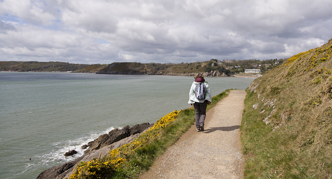
Past Limeslade Bay, a concrete pathway led around the next headland. The yellow gorse was in full bloom.

At the tip of the headland, a passing tourist took some pictures of us.


The community around the bend is called Langland Bay.

My father would have appreciated the fine woodwork on this bench.

Langland Bay has a sandy beach.

Hiking around the next headland.
Approaching Caswell Bay.

At Caswell Bay there is a fine sandy beach.

Beyond Caswell Bay the trail becomes a lot rougher. We hiked about halfway to Pwlldu before turning around and going back the way we came.

European robin.

Three Cliffs Bay to Oxwich Beach
To access this next hike, we took a bus from Swansea and got off in the vicinity of Three Cliffs Bay holiday park. I wasn’t sure exactly where to alight, but it worked out fine and we found a pathway down to Three Cliffs Bay. We caught Three Cliffs Bay on an outgoing tide, and there were acres and acres of sand.

To get to Tor Bay, the next beach, I had expected to have to climb over a headland, but as it turned out the receding tide let us slip around the base of the cliffs. Those cliffs, by the way, are Carboniferous limestones that were tilted by the Variscan Orogeny.

We skirted the base of the cliffs to reach Tor Bay.

We skirted around the next headland to reach Oxwich Bay Beach, a vast expanse of sand. We took a break at a driftwood log and we soaked up the sunshine.

Halfway along Oxwich Bay Beach, a stream required a detour inland. The bridge across the stream had been damaged by a recent storm, but it was still passable. At the far end of the beach was a cafe, and we bought some tubs of locally produced ice-cream.

Beyond Oxwich Bay Beach there is a forested headland. St. Illtyd’s Church is tucked into the forest beside the sea.

The woods were dotted with bluebells. We hiked to the tip of the headland and then went back the way we came.

On return, the way to Three Cliffs Bay was barred by the incoming tide.

We found a trail at the head of Tor Bay that led upward to a viewpoint. From this location I estimated it was going to be a 20 minute walk back to the road. The bus back to Swansea wasn’t due for a while, so we had a snooze in the sunshine whiling away extra time.

Rhossili Bay
Rhossili Bay Beach regularly makes an appearance on “top ten beaches of Britain” lists. So were keen to check it out. We took a bus to Rhossili, and as soon as we walked out of the village the views opened up.

The path followed the clifftops and let to a point. There were some feral ponies around.


At the tip of the peninsula are views of Worm’s Head, an islet that is connected to the mainland at low tide. It is possible to hike to the tip of Worm’s Head if you get the timing just right with respect to tides. The trail to Worm’s Head leads past a shack staffed with a lifeguard who makes sure people don’t get trapped by the tide. When we approached, the landbridge was exposed but the trail was closed – so not enough time available for the hike.

A foreshortened view towards Worm’s Head

It was time to descend to the beach.

Rhossili Bay Beach is a 4.5 km long sweep of sand.

Two-thirds of the way along, a stream crosses the beach, which is easy to cross where it flows through cobblestones. There was a driftwood log just perfect for sitting. Time for a cup of tea.


We hiked to the end and then back to the start.
Logistics
Swansea is easy to reach by train. You’ll likely have to make a connection in Cardiff or Newport.

We stayed in an airbnb in the Maritime Quarter of Swansea. Everything is within a short walking distance from there: the bus station, restaurants, supermarkets, shopping, and of course the beach.
We had considered staying in Mumbles, but Mumbles is not well connected to the rest of the Gower Peninsula. For many destinations you’d have to take a bus back to Swansea and connect there.